


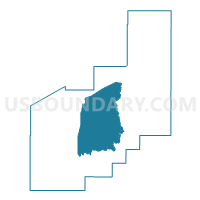
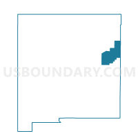
Quay County Precinct 6, Quay County, New Mexico
About
Outline

Summary
| Unique Area Identifier | 623818 |
| Name | Quay County Precinct 6 |
| County | Quay County |
| State | New Mexico |
| Area (square miles) | 437.06 |
| Land Area (square miles) | 436.16 |
| Water Area (square miles) | 0.90 |
| % of Land Area | 99.79 |
| % of Water Area | 0.21 |
| Latitude of the Internal Point | 35.04871720 |
| Longtitude of the Internal Point | -103.58551270 |
Maps

Graphs
Select a template below for downloading or customizing gragh for Quay County Precinct 6, Quay County, New Mexico


Neighbors
Neighoring Voting District (by Name) Neighboring Voting District on the Map
- Quay County Precinct 1, Quay County, NM
- Quay County Precinct 10, Quay County, NM
- Quay County Precinct 11, Quay County, NM
- Quay County Precinct 12, Quay County, NM
- Quay County Precinct 2, Quay County, NM
- Quay County Precinct 3, Quay County, NM
- Quay County Precinct 5, Quay County, NM
- Quay County Precinct 7, Quay County, NM
- Quay County Precinct 8, Quay County, NM
Top 10 Neighboring County Subdivision (by Population) Neighboring County Subdivision on the Map
- Tucumcari CCD, Quay County, NM (7,014)
- Logan-Nara Visa CCD, Quay County, NM (1,250)
- San Jon CCD, Quay County, NM (479)
- House-Forrest CCD, Quay County, NM (298)
Top 10 Neighboring Place (by Population) Neighboring Place on the Map
Top 10 Neighboring Unified School District (by Population) Neighboring Unified School District on the Map
- Tucumcari Public Schools, NM (6,943)
- Logan Municipal Schools, NM (1,323)
- Melrose Public Schools, NM (1,156)
- San Jon Municipal Schools, NM (476)
- Grady Municipal Schools, NM (340)
- House Municipal Schools, NM (258)
Top 10 Neighboring State Legislative District Lower Chamber (by Population) Neighboring State Legislative District Lower Chamber on the Map
Top 10 Neighboring State Legislative District Upper Chamber (by Population) Neighboring State Legislative District Upper Chamber on the Map
Top 10 Neighboring 111th Congressional District (by Population) Neighboring 111th Congressional District on the Map
Top 10 Neighboring Census Tract (by Population) Neighboring Census Tract on the Map
- Census Tract 9586.01, Quay County, NM (3,080)
- Census Tract 9589, Quay County, NM (3,018)
- Census Tract 9586.02, Quay County, NM (2,943)
Top 10 Neighboring 5-Digit ZIP Code Tabulation Area (by Population) Neighboring 5-Digit ZIP Code Tabulation Area on the Map
- 88401, NM (6,944)
- 88426, NM (1,212)
- 88124, NM (1,165)
- 88434, NM (369)
- 88120, NM (239)
- 88427, NM (119)